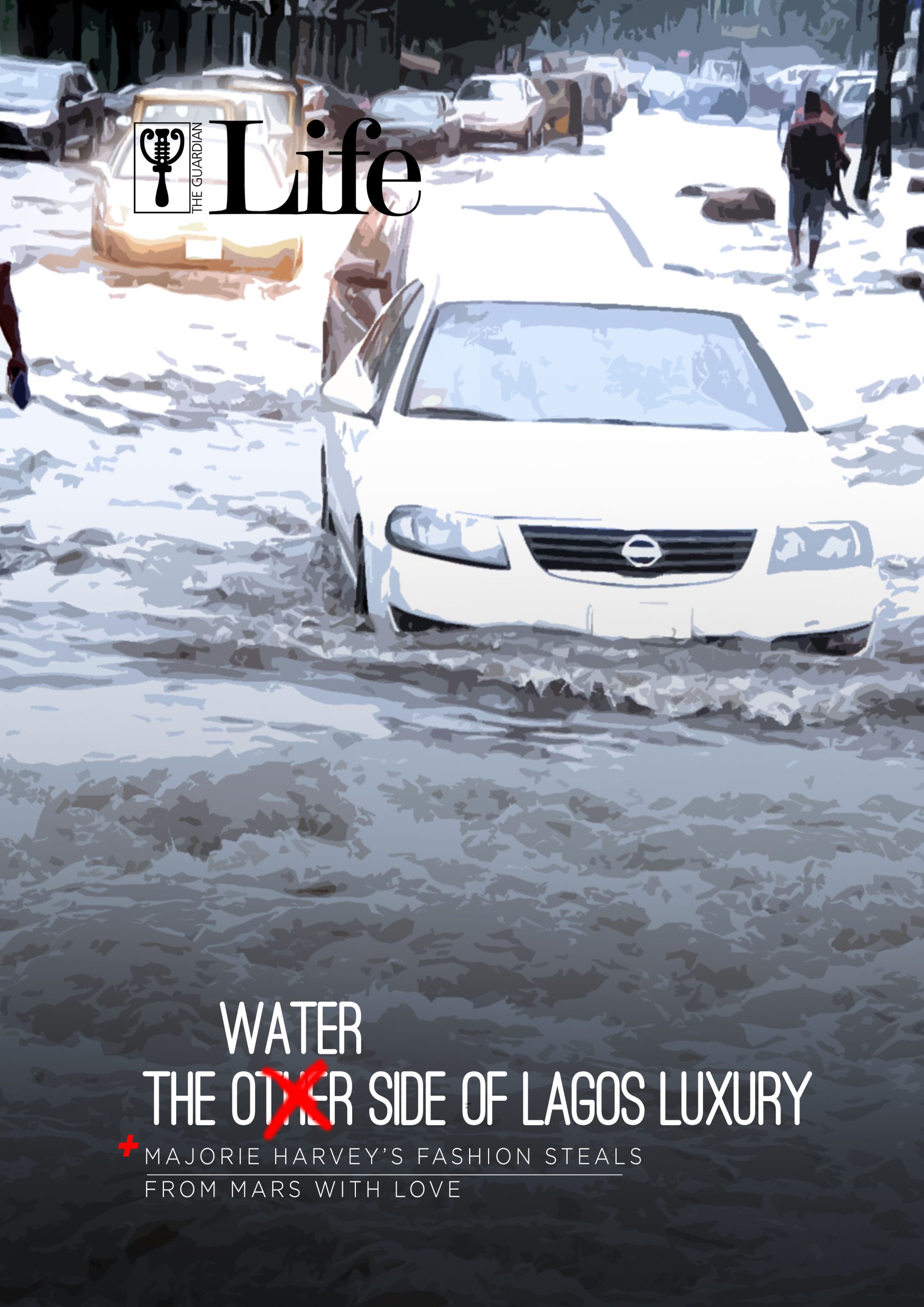
In 2017, a viral video of a man paddling his canoe on the Island, the bourgeoisie part of Lagos and home to a large percentage of the wealthiest Nigerians, surfaced on the internet. Although laughable at the time, it also revealed a stark reality: even the rich would not escape the lackadaisical approach to flooding.
In 2019, Abraham Adesanya Estate, Ajah became the focal example of flooding in Lagos after residents were seen using a canoe to gain entry into the estate.
On 10 July 2022, a day which began the celebration of Eid Il-Kabir, a Sport Utility Vehicle (SUV) and its occupants, except one, drowned in a flood in Agege, Lagos.
By today, Sunday, the rain and thunderstorm that was predicted to fall for about a week would have completed its course, but not without its far-reaching consequences.
Historically, the name ‘Lagos’, is a shortened form of the word, “Lagodikuramo” which means ‘calm-water’ or ‘Lakes’. It was given by the Portuguese when they first came around the region. They saw similarities between the Lagos from their hometown, which were surrounded by lakes and the one here.
[ad]
The island nature of Lagos is what defines it and gives prospects to all its supposed aspirations of becoming a Mega City of global repute. It’s no surprise then that lands along the Coastlines are sold and resold at a premium price. Almost the entire stretch of land from Victoria Island in Lagos down to Ibeju Lekki is littered with ‘resorts’ and luxury apartments which are either under construction or completed. The problem of coastline developments is that they either end up becoming victims or perpetrators of flooding. The most obvious solution developers of the coastline embark on is creating a high coastline wall. While that protects their development to some extent, it doubles the calamity of neighboring developments without such protections as tidal pressure from the coastlines travels along the wall to the other developments .
However, experts warn that Lagos, the commercial hub of Nigeria and one of the world’s most populous cities, may become inhabitable as sea levels continue to rise. “Inadequate and poorly maintained drainage systems and uncontrolled urban growth” contributes to this problem. And so far, the critics have been right.
[ad]
Flooding in Lagos, especially along the coast during the rainy season, has increased sporadically. The most hit are residents of Lagos Island, but flooding reports from the mainland are already catching up. The pattern for previous years has been consistent: at around the same time of the year, some areas of Lekki and Victoria Island in Lagos become a nightmare for both passage and living as the roads and buildings become flooded – sometimes reaching the lintel level. This is not to say that there aren’t other factors contributing to the flooding.
The fragile nature of the land on the island also contributes to the flooding. Olamide Udoma-Ejorh, a renowned Environmentalist and advocate for Cities, argues that Lekki should not be habitable as it is meant to be a marshland that collects water from the Lagos Lagoon in a bid to prevent flooding of the surrounding areas. Unfortunately, with the commercial capital cramping close to 8,000 persons per kilometre, a chronic housing deficit and people living on the Lagoon for generations, what is a marshland that they can’t live in?
The reality of most parts of Lagos being a marshland naturally exposes it to flood risks. For instance, sometime between October 2011 and January 2012, a resettlement scheme for the residents was proposed, as it is believed that the original master plan for that area was zoned as a wetland for agricultural purposes. However, an enormous housing shortfall, rapid population growth, as well as urbanization, has led to an organic conversion of the area to residential. The area is a catchment for the Ogun river, thereby exposing the lives and properties of the residents to the devastating effects of flooding whenever River Ogun floods its banks.
Lagos exposure systems to flooding is at critical levels and while some experts predict that up to 3 million Lagosians will be exposed to flooding by 2070, others argue that Lagos will become ‘Atlantis’ less than 30 years from now – a city completely submerged in water, thereby ceasing to exist! One thing is clear, however, that the flooding issue in Lagos is not one that should be brushed aside.
Way Forward
There have been efforts by the Lagos state government through the Ministry of Environment to carry out the annual clearing of primary and secondary drainage channels. Unfortunately, the process in itself ends up as a catalyst for further flooding, as they are mostly unsupervised. The time lapse between the team responsible for clearing the debris from the drainage channels and the other team involved in carting it away usually takes weeks. Within this period, some of the debris would have returned to the canal, as the clearing team usually dumps the debris right beside the channel. This issue can be simply solved by having the same team clear and cart away on the same day.
Beyond this, new drainage channels need to be built and extensive civil repair works need to be done to the existing channels. The master plan of private estates should also undergo scrutiny to ensure not only design standards are met but quality guidelines are also adhered to in implementations. And with about 40% of the city covered by wetlands and water, there is a high possibility that some of the future developments will either be made on ‘reclaimed land’ (aka lagoon or wetland).
At this point, the areas prone to flooding are already established but it seems like the efforts made to prevent flooding – or at least mitigate its effects – are inadequate as, at about the same time every year, the same places get flooded. According to the Lagos State Emergency Management Agency, the area most prone to flooding still remains Eti-Osa, with about 80 percent of the area at high risk. Half of the areas like Kosofe, due to its proximity to the Lagos Lagoon and the surrounding wetlands, Apapa, Ajeromi/Ifelodun and some parts of Amuwo Odofin which is at the mercy of the surrounding creeks, and heavy-duty trucks that damage the integrity of the roads, are also at risk of flooding.
One of the solutions experts proffer to flooding is “living with floods rather than fighting them”. This might sound counterintuitive on the surface, but taking into account key considerations like limitations or failures of traditional flood control measures, the need to tackle flooding that does not lead to displacement, and exploring ways to benefit from ordinary floods while mitigating extreme floods. This does not in any way dismiss the crucial need for structural measures, which include the channelization and use of natural and man-made barriers to contain waters in rivers and seas.
The use of flood vulnerability map can be utilized as a non-structural mitigation method to flooding. Data can be analyzed in real time from various data-points to anticipate possible flooding in high risk locations. These information can then be deployed through tech to alert residents living in vulnerable areas of an impending flood in their neighborhood so they can be better prepared.
Advising inhabitants of flood-prone areas and wetlands to prepare for potential flooding or relocate would go a long way in preparing them for what is largely inevitable.
Another solution would be to expand and connect existing drainage infrastructure within the city heartland. It is clear that the current drainage systems we have cannot handle the high rainfall that is associated with the city. More so, open drainage – especially within residential areas – poses even more risk of accidents or even drowning. More so, alongside debris removal from principal drainages within the city heartland (which should take place at least twice annually), there should be extensive sensitisation of residents – especially in rural areas – on the dangers of disposing of their wastes into canals with the hope that water will “carry it away”.
In addition, sensitisation should be made by urban planners to the public on which areas should be avoided for residential activities and, if possible, greedy developers building on wetlands should be prosecuted and also have their properties demolished.
Regulations should be created to protect all-natural wetlands as the vegetation serves as a break for flooding activities. Efforts to destroy the existing vegetation in such areas expose the soil to flooding risks. All the marshlands should be left as they are – uninterrupted by any human activity or occupancy.
[ad unit=2]