
 Get Guardian on Google
PORT Harcourt’s old township is more than a dated street plan. Its inherited parcel pattern, land claims, existing buildings, public infrastructure and colonial-era spatial hierarchy continue to shape who can use, improve and benefit from urban land. This article uses “deep property” as an analytical lens for these overlapping layers and considers whether Transfer of Development Rights (TDRs) could help conserve valued places while accommodating growth elsewhere. It recommends a community-informed zoning and title audit, followed by a small, legally enabled TDR pilot only where receiving areas can support additional density.
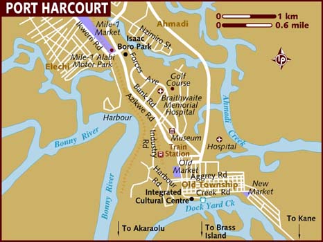
Port Harcourt was laid out in 1913–14 around the port and railway project that linked the coast to the coalfields and commercial hinterland. Historical accounts describe a spatial arrangement comprising the harbour, railway and warehouses, a commercial centre, the spacious Government Reservation now called Old GRA, and, southeast of the station, the African township—today’s Old Township—laid out on a tighter grid. The initial town area was acquired by local communities under colonial authority, and the history and terms of that acquisition remain part of the city’s contested land memory.
This pattern matters today because a plan is not simply geometry. Street widths, plot dimensions, building lines, drainage routes and the placement of public facilities influenced land values and development opportunities. Colonial planning standards also distinguished European and African quarters, including in plot size and servicing. Later growth, subdivision, rebuilding and informal adaptation have altered the original fabric, but the older layout still shapes access, density and the cost of upgrading. A planning response should recognise both the practical value of inherited infrastructure and the inequities embedded in its formation.
“Deep property” is not a defined Nigerian land-law category. In property scholarship, the phrase has been used to question whether ordinary freehold or leasehold concepts adequately describe layered interests in land and natural resources, including water and carbon. Applied here as an analytical, not doctrinal, term, it points to the multiple layers that coexist on an old township parcel: a statutory right of occupancy or other title evidence; customary or family histories and claims; zoning and development controls; building and infrastructure conditions; heritage and social value; and the public interest in safety, access and environmental resilience.
Consider a family plot on a narrow old-town street. The registered or documented interest may identify an occupier, but it does not by itself answer whether a rear addition blocks a drainage path, whether the building has heritage value, whether neighbours share access, or what density the current approved plan permits. Conversely, a planning map does not by itself resolve competing title or customary claims. “Deep property” is useful because it discourages treating any single document—whether a title, zoning map or historic plan—as the whole story. It does not create extra rights or override Nigerian law.
In this context, “underlying zoning” means the land-use designation and development envelope that apply to a parcel before a particular permit, variance or proposed bonus is considered. Depending on the operative plan and regulations, that baseline may specify permitted uses, density or plot ratio, height, setbacks, access, parking, environmental constraints and public reservations. Zoning must be distinguished from title: holding an interest in land does not automatically authorise every use or building form, and planning permission does not settle ownership.

For the old township, the practical question is which approved plans and rules are legally operative now, how they map to surveyed parcels, and how they have been amended or applied. Rivers State’s planning framework includes the Physical Planning and Development Law No. 6 of 2003; the Greater Port Harcourt City Development Authority was established under a separate 2009 law for the wider master-plan area. The exact jurisdiction, plan and development-control authority for each old-town parcel should be verified before any rezoning or TDR proposal. The existence of an old layout does not prove that every historical zone remains current law.
A transfer of development rights scheme separates the right to build at a specified intensity from the land itself. A planning authority designates “sending areas” where additional development should be limited—for example, a conservation block, a public open-space corridor or a flood-sensitive site—and “receiving areas” where extra floor area can be accommodated. A landholder in a sending area voluntarily accepts a permanent restriction on development and receives credit; a developer in a receiving area buys the credit and may build above the baseline, subject to a defined cap and other approvals. The credit is not a land title, a planning permit or automatic permission to build.
A hypothetical Port Harcourt pilot could designate a small group of historically significant buildings or a flood-risk drainage corridor as a sending area, after field survey and consultation. A receiving area might be a planned, serviced corridor outside the fragile historic street fabric. If its baseline allowed, for example, a four-storey building, a credit could permit a carefully capped fifth storey only after the authority confirms road, drainage, water, sanitation, power, fire access and public-space capacity. The sending parcel would receive an enduring registered restriction and a transparent, independently assessed credit value. This example is illustrative; no specific sending or receiving zone is proposed without current parcel and infrastructure data.
TDRs are not a general compensation device. The World Bank’s technical review cautions that a scheme needs real demand in receiving areas, careful design and attention to distributional effects; credits cannot simply replace compensation where government takes property. In a dense, infrastructure-constrained old township, transferring more floor area into an unsuitable receiving zone could worsen flooding, congestion and service failures. Credits may also benefit owners with clear title more readily than residents with customary, family or disputed interests unless eligibility and representation are designed fairly.
Rivers State and the Port Harcourt planning authorities should treat TDR as a planning instrument to test, not as an existing entitlement. The first step is to audit the baseline by publishing a parcel-level map linking current approved plans, zoning, title and occupancy records, easements, building conditions, infrastructure and flood exposure. Uncertainty should be recorded openly, and jurisdictional overlap resolved before zones are designated.
The process should then establish conservation priorities with affected residents, Rebisi and other relevant customary institutions, landholders, tenants, traders, professional bodies and heritage practitioners. It should identify the places and everyday uses communities want protected while documenting dissent and unresolved claims. A formal legal review should cover the 2003 Rivers planning law, the 2009 Greater Port Harcourt law where applicable, the Land Use Act 1978 and registration rules. If existing law does not clearly authorise transferable credits, enabling provisions and regulations should be enacted before trading begins. Those rules should specify voluntary participation, valuation, registration, appeals, credit expiry or retirement, anti-fraud checks and compensation rights separately.
Receiving areas should be chosen only where infrastructure and environmental assessments show that added intensity can be supported. Any bonus should be tied to enforceable requirements for drainage, water, sanitation, fire access, mobility, public realm and affordable or replacement housing where displacement risk exists. Implementation should begin with a small, time-limited pilot and a public TDR registry. Publishing transactions, prices, approvals, infrastructure contributions and distribution of benefits would allow the authorities and community to assess affordability, displacement, heritage outcomes and service performance before considering expansion.
The “enigma” of deep property is that a city parcel is never only a title or a zoning colour: it is also a lived place, an inherited pattern, an infrastructure burden and a set of claims that may not be equally visible in formal records. TDRs could help Port Harcourt preserve selected historic or environmental assets while directing growth to suitable locations, but only if the baseline zoning is current and transparent, receiving areas have capacity, affected communities shape the design, and the scheme rests on clear legal authority. The immediate recommendation is to map, consult, legislate where necessary, and pilot with public safeguards before any credits are traded.
Solomon Omoba is a Port Harcourt-based real estate consultant.