 Follow Us on Google News



 Follow Us on Google Discover
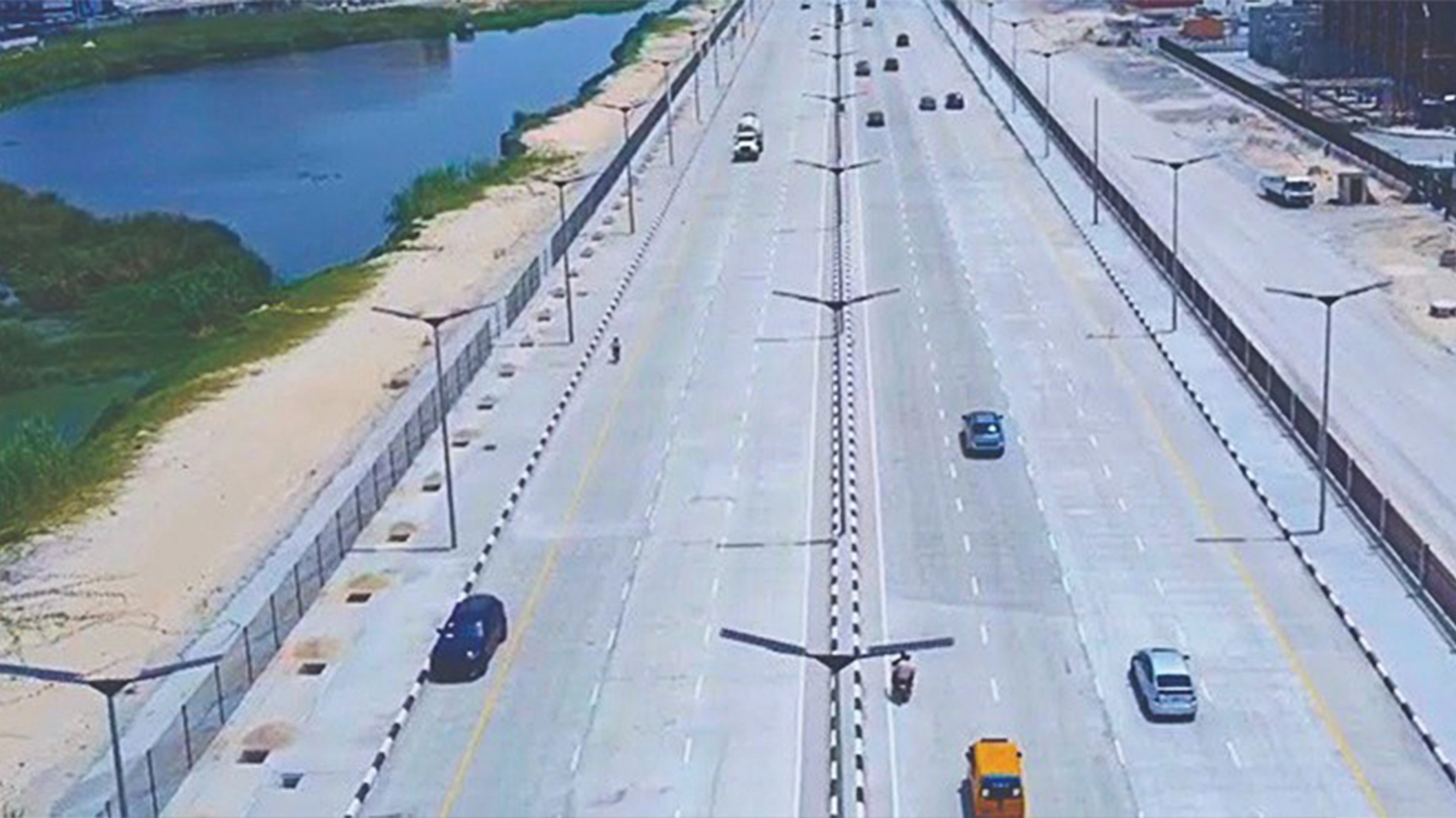
Conceived to boost connectivity, trade, tourism and economic development, the Lagos-Calabar Coastal Highway has sparked controversy over its alignment, coastal setbacks, environmental impact and implications for private investment. Experts, including town planners and environmental advocates, argue that the project requires a comprehensive coastal development master plan that integrates transportation, land use, tourism, environmental conservation and long-term urban growth, CHINEDUM UWAEGBULAM reports.
When the Federal Government unveiled the Lagos-Calabar Coastal Highway, it was presented as a transformative maritime corridor expected to unlock tourism, stimulate regional trade and connect coastal economies from Lagos to Cross River State. The project’s branding evoked images of a scenic shoreline drive that would open up beaches and waterfront communities to structured development.
However, as construction progresses, questions have emerged among residents, developers and urban planners about why a coastal highway appears to have little visible connection with the coast.
In several sections, particularly in Lagos, the alignment runs behind existing developments, sand-filled expanses and regulated setback zones, offering limited direct interaction with the Atlantic shoreline.
For stakeholders, the concern goes beyond aesthetics, raising fundamental questions about planning coherence, economic objectives, and investor confidence. At the centre of the debate is the enforcement of shoreline setback regulations along the corridor.
The Minister of Works, David Umahi, has defended the alignment, maintaining that coastal infrastructure must comply with environmental safety standards and right-of-way requirements.

Government officials argue that setbacks are essential safeguards against erosion, storm surges and rising sea levels, particularly amid the growing threat of climate change.
Perhaps no case illustrates the dilemma better than the demolition of parts of Landmark Beach Resort in Oniru, Lagos, to make way for the highway.
Once regarded as one of Nigeria’s flagship private beachfront tourism investments, the resort had developed into a thriving leisure and hospitality destination, attracting thousands of visitors annually.
Landmark Africa estimated that infrastructure worth about N42 billion was affected by the demolition, while the broader ecosystem represented an investment of approximately $200 million. Beyond the physical structures, the development supported more than 50 small businesses and over 1,000 direct and indirect jobs, highlighting the wider economic implications of the exercise.
Although the Federal Government maintained that the affected structures encroached on the highway’s right-of-way, the demolition reignited debate over planning coordination, investor protection, compensation and whether Nigeria’s drive for infrastructure development could inadvertently undermine its coastal tourism potential.
Umahi disclosed that the highway had been conceived in 1955 and gazetted in 2006. He said the ministry did not have a complete engineering design, subsoil investigation or other detailed technical documents covering the entire route.
According to him, engineering designs are developed for individual sections after environmental assessments and soil investigations have established the route, terrain, and technical requirements.
The minister noted that the original alignment through Lagos, Ogun, Ondo, Edo, Delta, Bayelsa, Rivers, Akwa Ibom and Cross River states remained intact. The ministry, however, added a stretch connecting the coastal highway to the existing East-West Road through Edo State.
Globally, shoreline setbacks are recognised planning tools designed to protect public infrastructure and private assets from environmental risks.
Controversy arises, however, when enforcement appears sudden or inconsistent with development approvals previously issued by state planning authorities. Property owners and developers argue that abrupt changes in interpretation create financial uncertainty, particularly where investments were made in good faith under existing approvals.
Urban development analysts identify two broad models for coastal highways. Some are designed as scenic routes that deliberately integrate ocean views, beach access and tourism infrastructure. Others function primarily as economic transport corridors, following alignments further inland to improve structural stability and ensure uninterrupted traffic flow.
Nigeria’s coastal highway appears increasingly aligned with the latter model. Yet the public narrative surrounding the project has emphasised tourism expansion, beachfront investment and hospitality development. This apparent disconnect between expectations and implementation has fuelled criticism. A road marketed as coastal but experienced as largely inland inevitably invites scrutiny.
Lagos’s Atlantic corridor has attracted substantial private investment in recent years, including beach resorts, leisure destinations, residential estates and commercial developments. Investors are now concerned that regulatory uncertainty, demolition threats and changing interpretations of setback requirements could discourage further investment.
In coastal economies, proximity to the water is not merely symbolic; it directly influences property values, tourism patronage and commercial viability. Changes to visibility or access can significantly affect projected returns. Where regulatory certainty is weak, investors may redirect capital towards markets with more predictable planning and development frameworks.
International examples offer useful lessons. California’s Pacific Coast Highway integrates scenic viewpoints and tourism facilities along cliffs and beaches, while Australia’s Great Ocean Road balances engineering resilience with tourism appeal, preserving panoramic ocean views while maintaining safety buffers.
In these cases, environmental protection, land-use zoning and investment expectations are generally addressed through planning and design processes. Where erosion risks necessitate moving roads inland, transparent master plans and compensation frameworks can help safeguard private interests and public access.
Nigeria’s experience exposes a recurring governance challenge: reconciling federal infrastructure priorities with state planning approvals and private development timelines. Questions remain about whether highway alignment decisions were adequately coordinated across the different tiers of government and whether investors received sufficient clarity about long-term setback requirements.
Urban planners argue that infrastructure development and tourism need not be mutually exclusive. Around the world, coastal highways improve accessibility while preserving public access to beaches, protecting existing investments where feasible and creating opportunities for waterfront recreation and hospitality.
For Nigeria, the task is to move beyond the debate over whether the highway should run closer to or farther from the coast and to establish how it can simultaneously serve transportation, environmental protection, and economic development objectives.
This requires a comprehensive coastal corridor development plan jointly coordinated by the Federal Government and affected states. Such a framework should clearly establish the highway’s right-of-way, scientifically justified coastal setbacks, tourism and commercial development zones, drainage requirements, ecological protection measures and public access points.
It should also provide transparent procedures for addressing existing property rights, planning approvals and compensation claims, while ensuring that future development complies with environmental and safety standards.
Ultimately, the success of the Lagos-Calabar Coastal Highway should not be measured solely by the kilometres of road constructed. It should also be judged by its contribution to sustainable coastal development, regional connectivity, tourism, environmental resilience and investor confidence. Without that broader planning vision, Nigeria risks building a major transport artery that delivers connectivity but falls short of the wider coastal development promise that helped define it.
The challenge, they insist, is not whether government should build critical infrastructure, but whether such projects are conceived within an integrated spatial development framework that balances environmental protection, mobility, tourism and private investment.
The Founder of the Nathaniel Atebije Foundation for Planning Advocacy, Mr Nathaniel Atebije, said there was no evidence that the Lagos-Calabar Coastal Highway was originally conceived as part of a comprehensive coastal master plan integrating transportation, land use, tourism, environmental management and long-term development along the corridor.
Atebije, a former president of the Nigerian Institute of Town Planners (NITP), said the Federal Government should have involved urban planners to assess potential developments and their impacts over the next 20 to 50 years, adding that inadequate physical planning contributed to the failure of many projects.
He said the highway should serve as the backbone of a planned coastal development system rather than encourage uncontrolled growth. He urged the government to engage planning consultants to prepare a comprehensive land-use plan for the corridor, despite the project’s advanced stage.
Atebije also advocated evidence-based coastal setbacks that reflect differences in erosion rates, shoreline characteristics, elevation and existing land uses. He called for clear demarcation of the highway’s right-of-way, the establishment of a special coastal corridor planning zone and guaranteed public access to the waterfront.
He warned that the current alignment and setback policy could undermine investment in beachfront tourism, hospitality and waterfront real estate if implemented without adequate consideration of local conditions.
Atebije therefore recommended a Lagos-Calabar Coastal Development Corridor Plan to be urgently developed by the Federal Government and the affected states, to connect planned development centres with conservation areas while balancing economic growth, environmental protection, and public safety. “The highway would become the transportation spine, while a series of planned development and conservation nodes would be connected to it,” he added.
The Chairman of the NITP, Lagos State Chapter, Dr David Olawale, said the coastal road had been incorporated into the Lagos State government’s development master plan in line with established planning principles, although its implementation was undertaken by the Federal Government.
According to him, the project follows the prescribed setbacks from the Atlantic Ocean. He urged the government to ensure that all developments along the corridor obtain the necessary planning permits and comply with approved setback requirements to protect the highway’s right-of-way, preserve public access to the coast, safeguard existing investments and promote waterfront tourism.
Olawale stressed the need for the government to consistently enforce planning standards and regulatory requirements for all developments along the corridor.
He added that a well-coordinated planning approach could enhance tourism and support sustainable development along the coastline, provided all relevant provisions and parameters in the master plan were properly implemented.
The President of the Pan African Vision for the Environment, Mr Anthony Akpan, said coastal setbacks should be determined by local environmental conditions, including erosion rates, wave energy, topography and projected sea-level rise, rather than a uniform 150-metre buffer. He noted that the Lagos-Calabar Coastal Highway traverses diverse coastal ecosystems, some of which face significant risks of erosion and flooding.
Akpan warned that the highway could disrupt natural drainage, tidal flows and sediment movement, potentially worsening inland flooding, accelerating coastal erosion and damaging mangrove ecosystems. He called for comprehensive environmental assessments, effective drainage systems and continuous monitoring to minimise ecological damage and strengthen climate resilience.
He advocated an integrated coastal management approach that balances environmental protection with tourism and private investment. This, he said, should include developing tourism facilities in less vulnerable areas, providing public beach access and adopting nature-based solutions such as dune restoration to protect the coastline and existing investments.
Citing international examples, Akpan said Nigeria could draw lessons from the United States’ Pacific Coast Highway, Australia’s Great Ocean Road and the Netherlands’ nature-based coastal protection projects.
He stressed that integrating environmental safeguards, sustainable tourism and sound planning could transform the Lagos-Calabar Coastal Highway into a resilient economic asset without compromising coastal ecosystems or public access.